The Santa Cruz County Coastal Rail Corridor:
Its best use is a Rail With Trail
Table of Contents
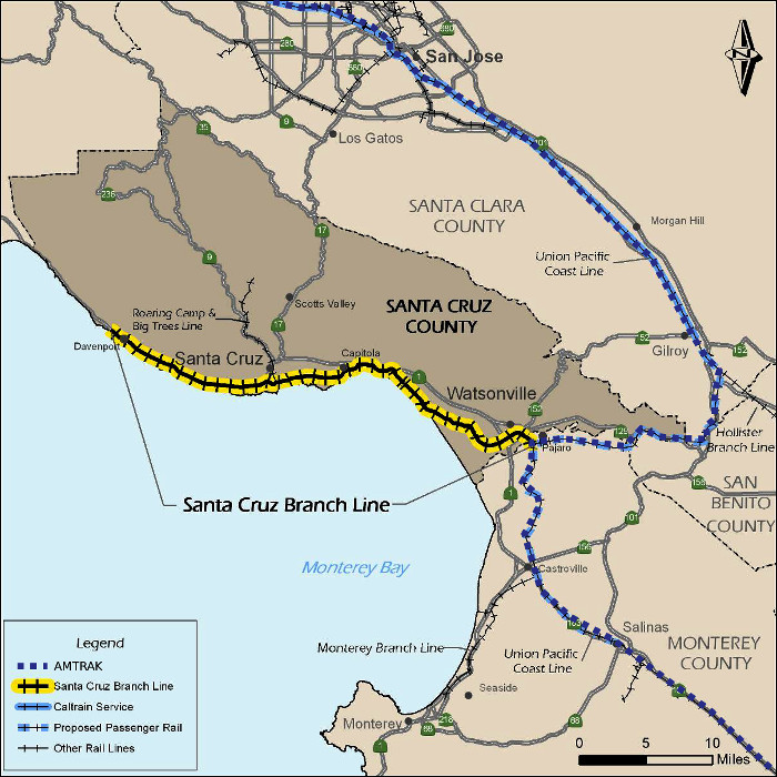
Our 32-mile rail corridor
Our 32-mile long rail corridor extending from the Pajaro Junction adjacent to Watsonville (where it connects with the coastal main line used by Union Pacific and Amtrak—see the map) northward to Davenport, was acquired from the Union Pacific Railroad by our Regional Transportation Commission (RTC) in October 2012. The $14.2 million purchase—unanimously recommended by the RTC in May 2010—was made primarily using the $22.5 million dollars available through (a) the passage of State Proposition 116 in 1990 by California voters—including a majority of Santa Cruz County voters ($11 million), (b) State Transportation Improvement Program funds ($10 million), and (c) a Federal grant obtained by Congressman Sam Farr (($1.5 million). Additional details, including conditions of purchase, are available from the RTC's website by clicking here.
Our Rail Line
The funds provided through Proposition 116 are mandated to be used to facilitate passenger and/or freight rail service on the line.
Historical background
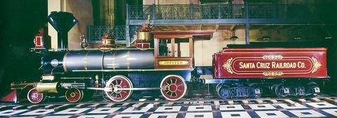
The Jupiter 3 locomotive at the Smithsonian
It is fortunate that this rail corridor exists. The first train to travel along the tracks—linking Santa Cruz with Watsonville—ran on May 7, 1876. The restored steam locomotive Jupiter~3 (which powered the train) is currently on display at the Smithsonian Institution. For more information, click here and here.
The line has been in almost continuous use since then. Over the years this rail line—now known as the Santa Cruz Branch Rail Line—has carried both passengers and freight, most recently providing freight service to and from the Davenport Cement plant with a frequency of approximately three round trips per week. Following the closure of the Cement Plant in 2009, the line's use decreased. At that point, Union Pacific became interested in selling the line, and the sale was made as described above.◀
The current situation
Since the corridor provides an alternative mode for transportation that is roughly parallel to Highway 1, it could serve as a beneficial multi-modal transportation corridor. The rail corridor passes through the most populated areas of Santa Cruz County between Santa Cruz and the Pajaro Junction. The population density along the corridor is surprisingly high, with roughly half of our population being located within a mile of the tracks.
In 2012, Iowa Pacific was selected to operate train service on the line, and is designated by the Federal Railroad Administration as the Common Carrier. Under a ten-year contract, it is now operating as the Santa Cruz & Monterey Bay Railway.◀
Plans for the rail trail are moving forward
Consistent with the RTC's goal to expand transportation use of the corridor, on November 7, 2013, the RTC adopted a Master Plan for the Monterey Bay Sanctuary Scenic Trail Network (MBSST), which includes a bicycle and pedestrian trail within the rail right-of-way (a rail trail adjacent to the tracks), as well as other connecting coastal trails and on-road facilities. Public interest in a bicycle and pedestrian trail lying within the rail corridor is clearly strong, and funding for the construction of initial segments of the trail has been allocated.


On August 6, 2015, the RTC accepted a grant award of $6.3 million in funds from the Federal Highway Administration’s (FHWA) Federal Lands Access Program for a 5-mile rail trail segment on our North Coast, extending from Wilder Ranch State Park to Panther Beach. As a condition of the grant, the RTC also committed to providing an additional $300,000 in matching funds for the $10,550,000 project. The Land Trust of Santa Cruz County is contributing $3 million and the California Coastal Conservancy is contributing $950,000. A press release may be viewed here. (Subsequent to this press release, the Land Trust agreed to assume the RTC's $300,000 commitment.)
Furthermore, three other segments of the Rail Trail have already received funding: (a) $4.06 million for the segment between Natural Bridges and Pacific Avenue within the City of Santa Cruz, (b) $300,000 for a short piece in Capitola from the Upper Pacific Cove parking lot to Monterey Avenue and (c) $1.04 million for the segment connecting Lee Road east to the slough trail connection within the City of Watsonville. The maps show the currently funded sections of the trail. Click on either map to enlarge it. Further details are availablehere.
As of June 2014, 217 Rail-With-Trail projects exist in the U.S., and the number is increasing. To learn more, click on this link. These projects are extremely safe and provide benefits to rail operators by providing fencing and channeling crossings to controlled areas. All of them are popular.◀
What's happening with passenger rail?
A Draft of a Passenger Rail Feasibility Study was released in May 2015 by our Regional Transportation Commission staff. The study was prepared by Fehr & Peers, LTK Engineering Services, RailPros and Bob Schaevitz. It is available by clicking on this link.
As noted in the 15-page Executive Summary (available here), the study, which analyzes seven sample scenarios, concludes that passenger rail service is feasible. The sample rail transit scenarios estimate a one-way fare of approximately $2.50 and headways of 30 minutes during commute hours. Weekday boardings for Scenarios G and G1 (Santa Cruz ⟺ Watsonville) are estimated to be approximately 5,500 when constructed (1.65 million per year), rising to over 7,500 by the year 2035. Capital costs for each of the scenarios range from $31.5 million for the Scenario S “starter” service (Santa Cruz ⟺ Seacliff) to $176 million for Scenario G1—the conventional locomotive-powered scenario for the full 20-mile service from Santa Cruz to Watsonville. Operation and Maintenance costs range from $3.7 million per year for Scenario J (Santa Cruz ⟺ Pajaro—weekday peak service) to $14.1 million per year for Scenario G1.
Here is a summary of projected train travel times for each of the seven sample scenarios:
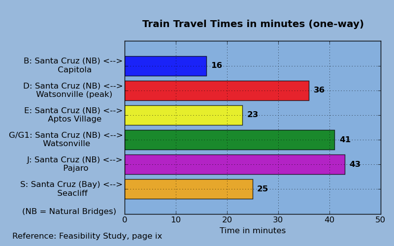
Figure 1
(Data from the Passenger Rail Feasibility Study)
It sounds promising. Nevertheless, questions are being raised. What follows are some of them. (The RTC also has a Frequently asked questions page. It is here.)◀
Frequently asked questions
-
Implementing passenger service on our rail line is way too costly. Why in the world would we spend so much just to get only a small number of travelers per day off of Highway 1?
The answer to this question has several parts:
Travel times are predictable: As Fig. 1 above shows, the train travel times are comparable to the car travel times on Highway 1, especially if there are traffic jams. Furthermore, those train travel times come with set schedules, and are not affected by highway traffic jams. If you're headed to a job, or to a class, you don't have to factor in the uncertainties of car travel. You'll know when the train leaves and when it arrives, and you can plan accordingly. Some destinations would require shuttle or bicycle connections.
Passenger rail is scalable: The capacity of passenger rail and freight modes can expand more easily as the population increases, compared to increases in the capacity of Highway 1. Rail use is scalable. More travelers on the rail line may be accommodated primarily by adding additional rail cars. (Some expansion of station capacities may be appropriate.) To accommodate more autos on Highway 1 requires the addition of expensive highway lanes, including new interchanges for through lanes, and added lanes will not be effective for long.
Travelers take up less space in a rail car: The capacity for travelers in a rail car is far more compact than the capacity for travelers in vehicles on a highway, especially for single-occupant vehicles.
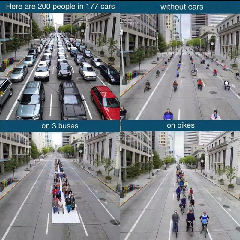
This image appeared on August 10, 2015 in The Washington Post. Their caption reads: “In cities, where space is rare and valuable, cars just don't make a whole lot of sense. The image, which uses photographs from a poster by International Sustainable Solutions taken by OnRequest Images in downtown Seattle, demonstrates that idea.”
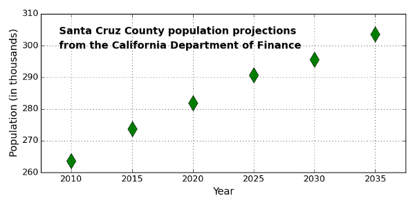
Planning for expansion is cheaper with rail: The population of the county is projected to increase, as shown by the graph. Smart planning mandates that we plan for an affordable transportation future, but expanding the capacity of Highway 1 by adding additional lanes to it is much more costly than implementing passenger rail service within the rail corridor. The cost of implementing passenger rail service is much less than the cost of accommodating increasing numbers of cars on Highway 1—especially over the longer term. (Expanding Highway 1 to six lanes from Santa Cruz to Aptos was recently estimated to cost approximately $600 million. This cost includes the reconstruction of interchanges so as to accommodate the additional pair of lanes.)
Passenger rail benefits seniors, youth, students and longer distance travelers: Over a third of our population do not drive cars, and that fraction is increasing. Passenger rail, like other public transportation modes, provides a way for those who do not or cannot drive to get from one place to another. Passenger rail and other modes—such as bicycles—can be combined to extend travel distances.
Rail cars are less polluting and reduce global warming: Rail cars, especially Light Rail Vehicles (LRVs), or Electric Multiple Units (EMUs)[1] are much less polluting than highway vehicles, and can therefore reduce the impact on global warming. The rail car technology is advancing rapidly. Try watching this video—an informational video about Alstom's new Citadis Spirit, due to become operational in 2018 in Ottawa. Alstom is the second largest manufacturer (behind Bombardier) of LRVs in the world.[2]
For additional information about Alstom's Citadis Spirit, check out this brochure. Note that these vehicles may be catenary-free, that is, without overhead wires. Furthermore, unlike the Siemens S70 vehicles shown below, they are 100 percent low floor, which is attractive both for those in wheelchairs and those with bicycles. Their maximum speed (65 mph) is also greater than that of the Siemens S70 (40 mph). Finally, they are remarkably efficient in their energy use, up to twenty times as efficient as the average passenger car in the U.S.[3]
An alternative choice of a Light Rail Vehicle, perhaps more familiar to us, is the Siemens S70. They are in use in several communities in the U.S. The City of Portland has just ordered 18 to add to its MAX train fleet. They will be manufactured in Sacramento. Here is a video that shows a shortened version of an S70 (a “streetcar”) in Sacramento. Unlike the Alstom vehicles above, they require overhead wires.◀
Passenger rail and highway traffic dynamics: The implementation of passenger rail can work to make use of the rail line an attractive option, providing an escape valve for those who repeatedly find themselves stuck in traffic on Highway 1.
To gain an understanding for this point, it helps to understand the dynamics of traffic flow on a highway. On a highway, the transition from traffic jam to freely flowing traffic is a phase transition. Such a transition occurs at a critical point (also called a tipping point). It happens suddenly. At the critical point, a small decrease in the density of vehicles on a highway can transform a traffic jam into freely flowing traffic, much as solid ice transforms to fluid water when the temperature is raised slightly.
For another good analogy, think of pouring rice grains through a funnel. If too many rice grains are being poured into the funnel, the flow of rice through the funnel jams, but near the critical point, a small reduction in the number of rice grains being poured in will allow the free flow of rice through the funnel. (This analogy is sometimes used to explain the effect of ramp metering.)
Thinking about these analogies, we can conclude that decreasing the number of vehicles slightly on the jammed highway will cause the disappearance of the traffic jam. While a transfer of only a small number of travelers from the highway to the rail could, in the short term, relieve jams on the highway, the long term effect is more complex, since a highway without traffic jams will attract more vehicles to the road. After some time, a new equilibrium point may be achieved, in which the highway will be at near capacity flow for some periods, but will likely still experience occasional traffic jams. However, there will also be new travelers on the rail line.
-
What about the problems of noise and vibration resulting from the frequent passage of trains on the rail line?
Passenger rail service on the line need not involve the use of the heavy noisy locomotives that typically haul freight trains. Lighter weight vehicles, such as Diesel Multiple Units (DMUs), or their electrical cousins Electrical Multiple Units (EMUs) or Light Rail Vehicles (LRVs), could be used on this line. (DMUs are recommended by the study.) DMUs are much quieter than Diesel locomotives. EMUs and LRVs are even quieter than DMUs. (A sound increase of 10dB is perceived by the human ear to be about “twice as loud”. Thus the noise from an average radio or vacuum cleaner (70dB) is perceived to be twice as loud as conversational speech (60dB). Santa Clara County's LRVs, manufactured by KinkiSharyo (Japan) and operated by the Valley Transportation Authority (VTA), are remarkably quiet, not much more than 70dB at 50 feet.)
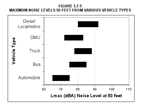
This figure, prepared for the Sonoma-Marin Area Rapid Transit (SMART) implementation, shows that a DMU is quieter than an ordinary Diesel-powered bus. (The full document from which this figure was obtained is here.) Such DMUs, such as the Swiss-made Stadler GTW, are currently in use on several commute lines in the U.S. A photo of a typical DMU is here. A thoughtful recent blog from Seattle is here.
What about the horns of rail vehicles? The horns of rail vehicles are mandated to sound at crossings, and can be quite loud. However, unlike the roar of a freeway,[4] noise from rail vehicles is intermittent, occurring only at the frequency at which the trains pass. Furthermore, some train horns (whistles, for example) have more agreeable sounds than others. Here are two you can try. To hear them, click on their names:
These are available, and could be installed on our vehicles. Furthermore, Quiet Zones can be mandated, which reduce train horn sounds in locations with enhanced crossing equipment. -
Federal regulations prohibit the use of light rail vehicles on the same track with freight trains. That seems like a show stopper. How can this problem be addressed?
The Federal Railroad Administration (FRA) prohibits the sharing, on the same track, freight trains with light rail vehicles. However, if there can be separation by time of day between the two types, a waiver to the rule can be granted by the FRA.
Since it is likely that freight service on the Santa Cruz Branch Line will be infrequent, especially in the section to the north of Watsonville, such time-separation seems a possibility. Freight trains could run at times when the light rail vehicles are not running. Many such waivers are now in effect in the U.S. Here is a relevant document from the Federal Transit Administration, which states:
“Where freight operations can be limited to times when LRT would not operate, such as late night, FRA has granted waivers to its rules. In this approach to temporal separation, FRA-compliant and non-compliant trains are kept absolutely separate by assignment of specific blocks of time to each mode, typically one non-compliant (traditionally LRT) block and one compliant (i.e., freight) block per 24-hour cycle.”
-
The space for a pedestrian and bicycle path seems too narrow in many places. Can't we just remove the tracks so as to provide the needed space?
First of all, based on the informational right-of-way maps,[5] approximately 94 percent of the corridor is at least 32 feet in width, and will easily accommodate both the rail tracks (20 feet) along with a full width trail (12 feet).
Of the remaing 6 percent (two miles), about one and two-thirds miles is greater than 25 feet wide, most of which will accommodate the rail tracks along with at least an 8-foot wide trail. Less than one-third of a mile, in small pieces at various locations, is narrower than the absolute minimum of 25 feet needed for a rail-with-trail system, but solutions have been identified.[6]
Second, it would be legally difficult. By agreement, the funds supplied through Proposition 116 must be used to enhance rail travel (freight and/or passengers) on the line, so removal of the tracks would be contrary to that agreement. Furthermore, Iowa Pacific, the carrier that currently runs the seasonal rail service, has another seven years left on their contract to do so and they have no intention of giving up their rights under that contract. Moreover, it is highly unlikely that the federal agency that must approve decommissioning the rail service would do so unless there was no rail carrier willing to step forward to provide passenger and freight service even after Iowa Pacific’s current contract expires. We have been told that the federal agency was formed to protect the rights of rail carriers, first and foremost, so decommissioning existing rail lines is not a easy accomplishment.[7]
Aside from that, the removal of the tracks and the redesign of the trail would be an expensive and involved process, and very likely would retard construction of the trail. We would not be able to plan and construct the trail any faster. Moreover, we would lose the advantages of the rail passenger service described above.
-
The Capitola trestle seems to be a real problem, since reportedly, it cannot accommodate a pedestrian and bicycle path in addition to the rail line. This seems like a stopper for the rail trail. What can be done about that?
Indeed, the rebuilding of the Capitola trestle (which actually has five parts) will likely be a difficult and expensive undertaking. Eventually the trestle will need to be reconstructed, and the most likely source of funding for that is actually grant money for rail projects. In the interim, there will be a gap. When funding becomes available and this gap is prioritized, a new single bridge accommodating both rail cars and a trail can be constructed. Keep in mind that the complete trail is being funded and built segment by segment, which means it will take some time before we have long sections of continuous trail. By then we should have a new trestle over Capitola.
-
When the La Selva trestle was reconstructed in February, 2015, no bicycle and pedestrian path was incorporated. Why not? This seems like a missed opportunity.
Part of the purchase of the rail corridor involved an agreement with Iowa Pacific that all parts of the rail line be in good working condition. The La Selva trestle was in very poor condition and needed to be replaced. Unfortunately, funds were not available to include a facility for bicycles and pedestrians in the reconstruction of the trestle. As funds become available, a separate bridge for bicycles and pedestrians will be constructed adjacent to the existing trestle. For additional information, see Page 4-83 of the Monterey Bay Sanctuary Scenic Trail Master Plan. Section 4 of this plan (a 20 MB document) is available here.
-
The Draft Passenger Rail Feasibility Study recommends further consideration be given only to Scenario E (Santa Cruz ⟺ Aptos Village) and Scenario S (Santa Cruz ⟺ Seacliff), neither of which would serve the south county, Watsonville in particular. Wouldn't it make sense to consider recommending service to Watsonville?
Table 7.1 of the Feasibility Study (Page 127) displays the overall scores for each of the seven sample scenarios analyzed, in terms of how well each scenario achieves the desired goals. As noted in that table, Scenario E ranks the highest (46) followed by Scenarios G and S, each at 38. Other scenarios score somewhat lower: B (37), J (36), G1 (35) and D (29). (Figure 1 above shows brief descriptions for each scenario.)
Section 8 of the Feasibility Study provides additional discussion, leading to the designation of the “preferred alternative service plans”: Scenarios E (option 1) and S (option 2). Of these two, the Study notes (Page 131) that “If and when funding becomes available, Scenario E can be expanded to Scenario G… ”. Presumably Scenario G was not chosen ahead of Scenario S because of its higher cost, and the funding for this scenario may not be sufficiently available in the short term.
However, RTC staff has heard from several Commissioners and Watsonville City Councilmembers that rail service to Watsonville is a high priority. This direction will be factored in to the Final Rail Plan and the RTC's recommendations for the next steps.◀
A proposal for a passenger train
Here is a proposal[8] that would implement Scenario E (Santa Cruz at Natural Bridges to Aptos near Cabrillo) with the intention for eventual extension to Watsonville as funds become available.
This proposal would use electrically powered Alstom Citadis Spirit vehicles—the type that have been chosen for Ottawa's O-Train Confederation Line, described in the video above. (The Passenger Feasibility Study recommends initially pursuing the use of DMUs, rather than electrically powered vehicles, presumably because the needed electrification of the line is judged to be too expensive. However, electrically powered vehicles contribute less to global warming, and may be quieter, so they should be considered from the start if possible.) As mentioned earlier, Alstom is a world-wide leader in the manufacture and installation of all kinds of rail systems. Vehicles would be made in the USA.
The Citadis Spirit vehicles are low-floored LRVs—also called trams—of excellent long-lasting design. Their use would require the electrification of approximately eight miles of track, possibly catenary-free, i.e., without overhead wires.
Our proposal envisions the acquisition of five vehicles initially, at an estimated cost of $4 million each. This would enable two trainsets of one or two vehicles each, plus one spare, so the vehicle cost would total approximately $20 million.
Rehabilitation and electrification of eight miles of track is estimated in the range of $60 million to $80 million, and the total capital cost is estimated at less than $120 million. Approximately half of that might be supplied by State and Federal grants, so that completing the project would require a local expenditure on the order of $60 million.◀
Concluding remarks
This piece was put together by members of The Campaign for Sensible Transportation, including Jack Nelson, Piet Canin, Amelia Conlen, Bruce Sawhill and Peter Scott.
What do you think of our “Proposal for a passenger train”, outlined above?
Does it merit further study?
Please write to us by clicking here.